Using a GPS app while you’re driving a car is a natural habit for most drivers—and the same should be true on the water. Finding a helpful, easy to use boat navigation app that incorporates user-generated information in real time is exactly what the KnowWake app provides for boaters all across the United States, Canada, parts of the Caribbean, Australia and New Zealand.
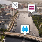
KnowWake is a free marine GPS app that’s compatible with both iPhone and Android that covers both coastal waterways and more than 350 inland lakes and rivers—including America’s Great Loop. Comparable to a Waze or Google Maps for the road, KnowWake’s platform creates a simple way to explore all the dockside and waterfront locations available by boat. Users will find everything from local restaurants, marinas, fuel docks, boat ramps, dive shops, inlets, dive sites, snorkel areas, and so much more.
Getting Started: Our Boat Navigation App
New boaters and experienced boaters alike will want to have access to the best boat navigation app right in the palm of their hand—and luckily, joining the KnowWake community has never been easier.
- To get started using KnowWake, simply visit either the App Store or Google Play on your own mobile device to download the app.
- Once downloaded, you’ll have an opportunity to create an account and customize your user profile. That’s when the fun begins.
- Choose an icon best suited for your vessel—anything from a personal watercraft (PWC) to a sportfishing boat, center console, sailboat, speed boat or even a yacht.
- Next, name your vessel!
- Finally, if you choose to do so, you can add in the address of your homeport.
And that’s it! It’s official, you are now a part of the KnowWake community.
Right away, you can start leaving your mark and contributing useful information to the KnowWake charts for other community users to access. Add information such as:
- Marine Life Sightings
- Hazards
- Raft Up Locations
- Patrol Locations
You’ll also have the ability to save your favorite “secret” spots that only you’ll be able to access, add new locations, and report map issues.
Wake Zones & Safety Features
One of the most popular features of KnowWake is our Wake Zone identifier. Difficult to understand wake zones will appear as either red, yellow, orange or green. This will help take all the guesswork out of whether or not you should be going fast or slow.
Red = Idle: Lowest speed to maintain steerage and forward motion.
Speed: 2-3 MPH/3-5 KM/H
Yellow = Slow: Little or no wake. Vessel must be completely settled in the water.
Speed: 5-7 MPH/8-11 KM/H
Orange = Tow: Allows vessels towing passengers the right of way and other high-speed activities.
Green = Normal: Resume normal safe speed according to current water traffic conditions.
Last but certainly not least, in case of an emergency, KnowWake users have the ability to utilize our S.O.S. safety feature.
Users can send out an S.O.S. for themselves or lend a hand to another boater that needs assistance. The highly visible S.O.S. icon is a great backup to your emergency position indicating radio beacon (EPIRB). If you ever see this icon on your chart, you know someone needs help. You should only use this feature if you are in trouble and need help.


